Autonomous inventory management for stockpiles
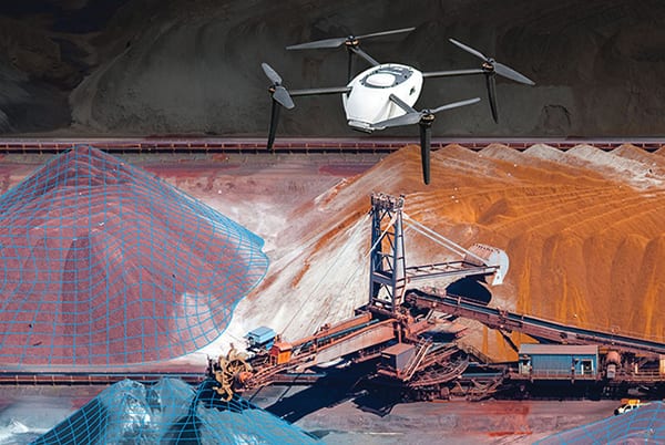
This company has launched an inventory-management solution (photo) for mining and aggregates companies to reconcile drone surveys with data from enterprise resource planning (ERP) and other systems of record for production and sales data. Bringing together drone-based topographic surveys, cloud-based analytics and inventory-management capabilities provides a single source of data to streamline operations. Included are capabilities to track specific products across multiple production sites, enabling users to more efficiently plan production and logistics for high-demand materials by identifying discrepancies in inventory data faster to avoid costly issues, such as overproduction. Teams in multiple locations can benefit from visibility into site-wide materials, enabling transparency across operations, sales, surveyors, engineers and management. Autonomous, on-demand drone flights over stockpiles reduce reliance on third-party or manual measurement and can provide volume calculations within 1–3% of true volume, says the company. Furthermore, drones can help to visualize the calculated base plane in three dimensions to ensure volumetric quality assurance and verify elevation changes and measure linear distances all from a single workspace. — Kespry, Menlo Park, Calif.
A compact drone equipped with geofencing safety capabilities
The PD6B-Type II (photo) is a large-platform aerial drone equipped with a geofence system and a built-in safety unit. When deviating from flight safety range or altitude, it is possible to self-activate a parachute to make the drone land safely. The PD6B-Type II comes with a maximum payload of 30 kg (66.1 lb) in a compact design that make it easy to carry and deliver. It adopts a layout in which the propeller does not wrap when spreading by reversing the mounting direction of the adjacent motor. As a result, the distance between the shafts is shorter than the previous six-rotor machine. The overall height is 550 mm and the machine weighs just 11.5 kg. The PD6B-Type II’s smooth flight and interchangeable battery packs makes it possible to acquire survey data using laser sensors with high precision. The drone’s maximum speed is 60 km/h and it can operate in wind speeds up to 10 m/s (22.4 mph). — ProDrone Inc., Mountain View, Calif.
New software applies machine learning to drone imagery
Map Engine (photo) is a new machine-learning-driven photogrammetry software that generates high-resolution maps and 3-D models from drone imagery. The new processing engine leverages the latest cloud infrastructure and machine-learning technology to deliver high-quality results and help users reduce hardware and maintenance costs, says the company. The new Map Engine release now generates maps and models 30–50% faster than previous versions of the software, says the developer. Scenes made up of hundreds of images can be processed in under an hour. Mobile-upload capabilities enable users to wirelessly transfer images to the cloud. — DroneDeploy, San Francisco, Calif.
A full suite of autonomous inspection and testing services
This company’s inspection platform involves automated testing services with robotic crawlers, unmanned aerial vehicles (UAVs) and autonomous underwater vehicles (AUVs), combining advanced predictive analytics, digital-inspection data warehousing and intelligent inspection-planning recommendations. Using aerial, ground and underwater sensors attached to robots to collect vital inspection data and recommend targeted, risk-based inspection scheduling and planning, the Avitas cloud-based inspection platform centralizes and stores the data, allowing for archival searches of inspection records. 3-D modeling software allows for targeted robotic paths that can be repeated to detect asset changes over time. Inspection data from both manual and autonomous inspection can be combined with asset-performance data, external data sources (such as climate conditions) and new inputs from subsequent inspections. Advanced algorithms automatically detect asset defects and anomalies, and as more data are ingested across diverse sources, the deep-learning models, stored on the company’s AI Workbench, retrain for smarter actionable insights. — Avitas Systems, a GE Venture, Boston, Mass.
Modular fuel-cell technology enables longer drone flights
The lightweight 650W fuel-cell power module (FCPM; photo) has been specifically designed for the commercial drone market and offers considerably longer flight time when compared to traditional batteries. Flight time is one of the key pain points for commercial drone operations. Key benefits of the 650W FCPM include increased productivity, less downtime owing to quick refueling and increased payload capability. The FCPM can be used as a standalone product, or combined with another module to provide up to 1.3 kW of power. The FCC-compliant product is commercially available and is suitable for a variety of unmanned aerial vehicles, including multi-rotor and fixed-wing. The module runs on hydrogen and ambient air to produce clean power in a simple, cost effective, robust and lightweight package. It can be integrated into UAV platforms without compromising payload, according to the manufacturer. — Intelligent Energy Ltd., Leicestershire, U.K.
Software for navigating aerial inspection data
Magnet Inspect (photo) is a new software designed to facilitate data processing workflow for UAV-aided inspection. The software efficiently manages large UAV data sets to create inspection reports. Compatible with models from virtually any UAV, the software enables operators to efficiently navigate, annotate and create reports with inspection photos, creating an end-to-end inspection workflow. Magnet Inspect is designed to allow operators to visually navigate UAV photos, aligning 3-D reality meshes with raw georeferenced images in one location and filtering them based on selected criteria, including field of view. Images from the inspection can be flagged to indicate whether there are issues, and annotated with built-in free-hand graphical tools. — Topcon Positioning Group, Livermore, Calif.
Safer air sampling for accurate emissions monitoring
The DR300 Flying Laboratory (photo) is a sampling drone that can be used to sample ambient air at heights of up to 125 m above ground level or directly sample from stack plumes. Height sampling and direct plume sampling can be used to increase accuracy of emissions assessments. When using the DR300 sampling drone, operators can stay safely away from hazardous sources while acquiring environmental samples. The DR300 can be flown into the plume of a flare to take direct samples to analyze chemical composition. Temperature and humidity of the plume are also measured for dispersion calculations. DR300 air-sampling drones provide remote monitoring of more than 50 chemicals. Data from onboard sensors are transmitted to an operator’s tablet for live viewing and logging. The DR300 kit includes the drone itself, along with a remote controller, standing legs, sampling probe, three custom-made sampling bags, a set of spare rotor blades, a battery charger and spare battery pack and more. The sampling drone can be operated in temperatures up to 70°C. According to the company, it is possible to sample from a source under negative pressure. — Scentroid, a Division of IDES Canada, Stouffville, Ont., Canada